Our brand promise is precision and reliability. It shows our commitment to deliver products and solutions that are highly accurate, reliable, and developed to meet the needs of customers in our business areas: surveying, Construction & Software Development.

 +91 88672 89167 : +91 90001 - 23681
 info@bharat-associates.com
It is a long established fact that a reader will be distracted by the readable content of a page when looking at its layout. The point of using Lorem Ipsum is that it look like readable English.
To use our decades of experience to build lasting relationships and to be a reliable partner in offering high precision positioning solutions.
We, Bharat Associates &Consultancy would like to introduce ourselves, with dignity and pride, as one of the experienced & well reputed firms in India, for providing complete Geospatial solutions to our clients with Land Surveying, Mapping & GIS requirements, by ‘state of the art’ modern technology using DGPS, Total Stations, High Resolution Satellite images / Aerial photogrammetry.
Our company was established in 2004, managing by Mr. N Venkateswarlu, he having 15 plus years Technical and functional experience) and well expertise in Modern Surveying Technology, GIS packages of Autodesk, MapInfo and Arc GIS etc.) And
Mr. M.V Jayaraj is having 38 years of experience in Surveying and geo technical investigation, is worked for 1.5 years as quality controller (Engineer) Manager in infrastructure Company.
Surveying and Mapping is a high-tech, multi-disciplined function that precisely establishes and maps in two or three dimensions, the exact locations of land-based sites, facilities or boundaries. The surveying and mapping services have undergone significant technological advancements and currently utilize GPS (Global Positioning System), GIS (Geographic Information System) as well as the traditional total station surveying methods.
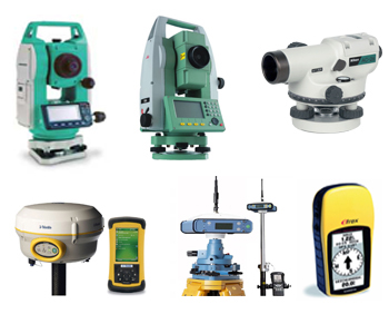
We have wide variety of Survey Instruments & Equipments at our disposal, including latest Trimble dual frequency DGPS, LIECA Total Station Instruments, Auto levels etc. In additions to field survey equipments, we are also having our workstations Laptops, Printer, scanner & copier. Our company offers services in two aspects of Land Surveying, Mapping & GIS i.e. Consultancy and or Execution of task. We shall be able to carry out various tasks with required accuracy and optimum cost effectiveness. Our goal is to live up to our client’s expectation & thereby fully justifying their trust in us.
Surveying Instruments
10 No.s Total Stations
30 No.s GPS's
Trimble R4 DGPS
South RTK DGPS